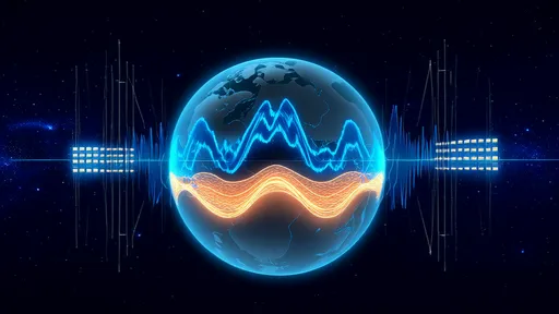
Earth's Inner Symphony: How Seismic Waves Reveal Our Planet's Hidden Layers
The Earth beneath our feet holds mysteries far beyond what human eyes can perceive. Like physicians using ultrasound to examine a patient's internal organs, geophysicists employ seismic waves as their diagnostic tool to create detailed images of our planet's hidden anatomy. This remarkable technique, often called "seismic tomography," allows scientists to construct three-dimensional maps of Earth's interior structure with astonishing precision.
When an earthquake occurs, it releases energy that radiates outward in all directions through the Earth's layers. These vibrations travel at different speeds depending on the density, temperature, and composition of the materials they pass through. Sensitive instruments called seismographs stationed around the globe record these waves, capturing their arrival times and amplitudes with meticulous accuracy. By analyzing these subtle variations, researchers can infer the properties of materials deep within the Earth that no drill could ever reach.
The process resembles medical CT scanning in its fundamental approach, but operates on a planetary scale. Where a hospital scanner might image a human brain using X-rays from multiple angles, seismic tomography uses earthquake waves that have traversed the planet along thousands of different paths. Powerful computers then process this massive dataset to reconstruct what lies beneath - revealing mountain ranges at the core-mantle boundary, descending slabs of ancient ocean floor, and plumes of hot material rising from the deep interior.
Modern seismic imaging has uncovered startling features that challenge our understanding of planetary dynamics. One such discovery is the existence of two gigantic "blobs" each the size of a continent, located deep above Earth's core. These structures, formally called Large Low-Shear-Velocity Provinces (LLSVPs), appear to be made of different material than the surrounding mantle and may represent relics from Earth's earliest history. Their exact nature remains debated, but seismic waves clearly show them distorting the flow of mantle material like boulders in a stream.
Beyond mapping static structures, seismic tomography provides insights into Earth's ongoing geological processes. The technique has revealed how subducting tectonic plates sometimes stall mid-mantle before continuing their descent, and how some volcanic hotspots connect to deep mantle plumes while others have more shallow origins. These findings have revolutionized our understanding of plate tectonics and volcanism, showing that Earth's surface activity is intimately linked to movements occurring thousands of kilometers below.
The quality of seismic images continues to improve as technology advances. Where early studies could only reveal broad patterns, modern arrays of sophisticated seismometers can detect variations on scales of just a few kilometers, even at great depths. New computational techniques allow researchers to extract more information from each seismic wave, including its frequency content and polarization. Some teams are now applying machine learning algorithms to identify subtle patterns in the data that might elude human analysts.
Recent innovations include "ambient noise tomography," which uses the constant background vibrations of Earth - from ocean waves, atmospheric disturbances, and human activity - to image structures when no earthquakes are occurring. This approach has proven particularly valuable for studying stable continental regions where earthquakes are rare but geological questions abound. Other researchers are developing portable seismic arrays that can be deployed quickly to study specific regions in unprecedented detail.
As our seismic imaging capabilities grow, so does our appreciation for Earth's dynamic interior. The planet is revealed not as a static ball of rock, but as a complex, evolving system with its own rhythms and cycles. Seismic waves provide the soundtrack to this hidden drama, allowing us to "listen" to processes that shape our world over millions of years. Each new earthquake adds another note to this planetary symphony, helping scientists compose an ever-clearer picture of the world beneath our feet.
The implications extend beyond pure scientific curiosity. Understanding Earth's interior structure helps assess earthquake risks, locate mineral and energy resources, and even provides clues about how other planets might have formed. As climate change alters surface conditions, seismic monitoring may also help track how these changes affect the deep Earth - completing the connection between what happens above ground and the planetary-scale processes below.
Looking ahead, the field of seismic tomography stands poised for transformative discoveries. Plans for next-generation seismometer networks promise global coverage with unprecedented resolution. Ambitious projects aim to image the core-mantle boundary in detail or track the movement of melt within volcanic systems. Some scientists speculate that future advances might even allow us to detect chemical variations directly, rather than inferring them from wave speed differences.
What began a century ago as crude measurements of earthquake arrival times has blossomed into a sophisticated discipline that peers deep into our planet's heart. The images produced by seismic tomography represent more than scientific achievement - they reveal the hidden anatomy of our world, showing that even the most familiar planet can still surprise us. As the technology continues to evolve, each new seismic snapshot brings us closer to understanding Earth as a complete system, from crust to core.

By /Jun 19, 2025

By /Jun 19, 2025
By /Jun 19, 2025

By /Jun 19, 2025

By /Jun 19, 2025

By /Jun 19, 2025
By /Jun 19, 2025

By /Jun 19, 2025

By /Jun 19, 2025

By /Jun 19, 2025
By /Jun 19, 2025

By /Jun 19, 2025

By /Jun 19, 2025

By /Jun 19, 2025

By /Jun 19, 2025
By /Jun 19, 2025

By /Jun 19, 2025